วันเสาร์ที่ 24 ตุลาคม พ.ศ. 2552

Loy Krathong Festival


Loy Krathong is held on the full moon of the 12th month in the traditional Thai lunar calendar. In the western calendar this usually falls in November.

"Loi" means "to float". "Krathong" is a raft about a handspan in diameter traditionally made from a section of banana tree trunk (although modern-day versions use specially made bread 'flowers' and may use styrofoam), decorated with elaborately-folded banana leaves, flowers, candles, incense sticks etc. During the night of the full moon, many people will release a small raft like this on a river. Governmental offices, corporations and other organizations also build much bigger and more elaborate rafts, and these are often judged in contests. In addition, fireworks and beauty contests take place during the festival.


The festival probably originated in India as a Hindu festival similar to Deepavali as thanksgiving to the deity of the Ganges with floating lanterns for giving life throughout the year. According to the writings of H.M. King Rama IV in 1863, the originally Brahmanical festival was adapted by Buddhists in Thailand as a ceremony to honour the original Buddha, Siddhartha Guatama. Apart from venerating the Buddha with light (the candle on the raft), the act of floating away the candle raft is symbolic of letting go of all one's grudges, anger and defilements, so that one can start life afresh on a better foot. People will also cut their fingernails and hair and add them to the raft as a symbol of letting go of the bad parts of oneself. Many Thai believe that floating a krathong will create good luck, and they do it to honor and thank the Goddess of Water, Phra Mae Khongkha (พระแม่คงคา).


The beauty contests that accompany the festival are known as "Noppamas Queen Contests". According to legend, Noppamas was a consort of the Sukothai king Loethai (14th century) and she was the first to float decorated krathongs. The Loi Krathong festival is also associated with the start of vegetable carving.

The Thai tradition of Loy Kratong started off in Sukhothai, but is now celebrated throughout Thailand, with the festivities in Chiang Mai and Ayutthaya being particularly well known.


In Chiang Mai Loi Kratong is also known as "Yi Peng". Every year thousands of people assemble to float the banana-leaf krathong onto the waterways of the city, honouring the Goddess of Water. A multitude of Lanna-style sky lanterns (khom fai) are also launched into the air where they resemble large flocks of giant fluorescent jellyfish gracefully floating by through the skies. These are believed to help rid the locals of troubles and are also taken to decorate houses and streets.

Kelantan also has the same celebration, especially in the Tumpat area. The ministry in charge of tourism in Malaysia recognises it as an attraction for tourist. Many people visit the celebration each year.

วันจันทร์ที่ 22 มิถุนายน พ.ศ. 2552

Thailand land of smile.


Attractions


Thailand offers a great variety of attractions. These include diving sites, sandy beaches, hundreds of tropical islands, varied night-life, archaeological sites, museums, hill tribes, exceptional flora and bird life, palaces and World Heritage sites. Many tourists follow courses during their stay in Thailand. Popular are classes in Thai cooking, Buddhism and traditional Thai massage. Thai national festivals range from the fun-for-all water splashing Songkran to the almost fairytale like quality of Loy Krathong. Many localities in Thailand also have their own festivals. Famous are the "Elephant Round-up" in Surin, the "Rocket Festival" in Yasothon and the curious "Phi Ta Khon" festival in Dan Sai.

Thai cuisine has become deservedly famous worldwide with its enthusiastic use of fresh herbs and spices. From an inexpensive plate of delicious Som tam at a simple street stall upcountry to a modern take on Thai cuisine in the gourmet restaurants of Bangkok, it's very difficult not to eat well in Thailand.

Only the most austere ascetics can resist shopping when in Thailand. Bangkok is renowned for its main shopping malls down town (with CentralWorld being the biggest shopping mall in South-east Asia), offering an astounding variety of international and local brands. Towards the north of the city, and easily reached by Skytrain or underground, is "Chatuchak Weekend Market". It is possibly the largest market in the world, selling everything from household items to live, and sometimes endangered, animals. The "Pratunam Market" down town, is nearly totally specialised in fabrics and clothing. The night markets in the Silom area and on Khaosan Road are mainly tourist orientated, selling items such as T-shirts, handicrafts, counterfeit watches and sunglasses. In the vicinity of Bangkok one can find several visually stunning "Floating markets". The "Sunday Evening Walking Street Market", held on Rachadamnoen road inside the old city, must be the shopping highlight of a visit to Chiang Mai up in Northern Thailand. It attracts many locals as well as foreigners. The "Night Bazaar" is Chiang Mai's more tourist orientated market, sprawling over several city blocks just east of the old city walls and moat.


วันอาทิตย์ที่ 21 มิถุนายน พ.ศ. 2552

Pattaya land of Entertainment.


Pattaya (พัทยา) is a popular resort on the North Gulf Coast of Eastern Thailand, 150 km south-east of Bangkok. Pattaya is most famous for its go-go and beer bars, but besides the men and women on offer the place has made efforts to provide more family-friendly attractions and activities. Although the sex industry is still going strong in Pattaya, it also attracts local families and holidaymakers from far and wide. Efforts by the local authorities over the past few years have improved the quality of the beaches, but they are still lackluster by Thailand's high standards, and over-development has long since destroyed some of the natural charms it once had. However, the plethora of hotels and guest houses and easy access from the capital and airport make it a popular weekend getaway. Catering for over 5 million tourists yearly, Pattaya is also able to offer an excellent range of eating choices and a wide variety of things to do and see, and its population is a colorful potpourri of mixed nationalities from near and far.


Districts

"Greater Pattaya" occupies most of the coastline of Banglamung (one of the eleven districts that comprise Chonburi Province). It is divided into a larger northern section which spans the areas to the east of Naklua Beach (the most northern beach) and Pattaya Beach (the main beach) plus the Buddha Hill headland (immediately south of Pattaya Beach), and a smaller southern section covering the area to the east of Jomtien Beach (which lies directly south of Buddha Hill) including Dongtan Beach. Jomtien's beaches are much broader and generally in better shape, and the atmosphere locally is more sedate and family-oriented, than at Pattaya Beach.


Sub-districts


Pattaya's coastal side is divided longitudinally into five contiguous sub-districts (or six, if also including Jomtien). Each one is named after the section of beach or headland at its seaboard.

In the middle are the three Pattaya Bay sub-districts, which share the main Baht Bus route (so most places are within 5 minutes / 10 baht of most other places, at any hour) and have much else in common, and hence in combination make up the main quasi-downtown zone:

North Pattaya (Pattaya Nua) - not the northern-most part of Pattaya (as Naklua lies further north), but the section of Pattaya adjacent to the northern end of Pattaya Beach and extending inland to both the north and south of North Pattaya Road. Does not include Naklua.

South Pattaya (Pattaya Tai) - not the southern-most part of Pattaya (as the Buddha Hill headland, and then Jomtien, lie further south), but the section of Pattaya adjacent to the southern end of Pattaya Beach and extending inland to both the north and south of South Pattaya Road. Includes Pattayaland and Walking Street. Does not include Buddha Hill or Jomtien.


Central Pattaya (Pattaya Klang) - not the dead center of Pattaya, but the section of Pattaya adjacent to the middle of Pattaya Beach and extending inland to both the north and south of Central Pattaya Road. Some maps/guides disregard the Central Pattaya convention, and instead extend North Pattaya and South Pattaya to meet each other along Central Pattaya Road; sometimes, Beach Road is described with a similar division, and the respective halves given "North Beach Road" and "South Beach Road" monikers.
Flanking the Pattaya Beach sub-districts are:

Naklua - immediately north of North Pattaya, and with quick, frequent, and inexpensive transport to and from the rest of Pattaya; Naklua is popular with visitors whose native language is German. In terms of tourism-related locations, it's the smallest and least significant sub-district, the main attractions being the beaches (which are quieter than Pattaya Beach) and the Sanctuary of Truth.


Buddha Hill - named after the Buddha Hill landmark and sandwiched between South Pattaya (to the north) and Jomtien (to the south); to the east, South Pattaya and Jomtien meet directly.
In practice, exactly where each sub-district ends and the next begins is a very grey area as none of the boundaries lie along major roads (and none of the many readily available tourist maps attempts to define boundaries at this level); nevertheless they do provide a handy rough guide to approximate latitude. Further inland, the sub-district names are used less, and locality/road names take precedence - for example, an address might state "Sukhumvit, Naklua" which is useful in that it makes it clear the location is to the north of the Sukhumvit / North Pattaya Road intersection, however the exact same place would not normally be described simply as being "in Naklua" as that would give the misleading impression of it being in the main beachside/tourism area further west.


For more information visit here >>> http://wikitravel.org/en/pattaya

วันพุธที่ 17 มิถุนายน พ.ศ. 2552

Chang Island (Ko Chang)


Ko Chang (Thai : เกาะช้าง), also Koh Chang is the second largest island of Thailand (largest island in the Ko Chang Marine Park archipelago), located on the Thai east coast 310 km away from Bangkok near border to Cambodia in the Gulf of Thailand. The name means Elephant Island. Ko Chang was named for the elephant shape of its headland, although elephants are not indigenous to the island. At present, there are 8 villages in total. It is a mountainous island and Khao Salak Phet is the highest peak of all at 744 metres. Visitors are also met with several waterfalls, splendid reefs and rainforests. The island has an area of approximately 217 square kilometers. Ko Chang was previously an unsettled island but it is now important as a harbour for ships to escape from the monsoon, and dietary or fresh water resources, especially at Ao Salak Phet or Ao Salat which is well known to pirates, Hai Lam Chinese and Vietnamese.


The island is part of the Mu Ko Chang Marine National Park. During World War II, when Thailand was occupied by the Japanese, Ko Chang was the scene of a naval battle between the reluctant Royal Thai Navy and a Vichy France squadron, in which the Thais were decisively beaten.


Until the mid-1980s the infrastructure on the island was undeveloped, but tourism has increased significantly since then. Around the year 2000, malaria was eradicated, the area became a national park (and began charging entry fees). The island now receives 655,000 visitors annually, about two thirds of them Thai. Ko Chang is one of the few places with virgin forest, but the rush to cash in on tourism has had a heavy toll on its virgin forest. Land prices have skyrocketed. there are also beautiful if not high end resort now popping up all over the island.


Climate


Ko chang has three seasons, they are:


  • Cool season (Nov-Feb)


  • Hot season (March-May)


  • Rainy season (June-Oct)


Due to its location and being an island, Ko Chang does get more than its fair share of rain, 4,000 mm. per year.


Transportation


Air


Ko Chang has no airport. The nearest airport is in Amphoe Muang Trat on the mainland. Koh Chang Air Taxi however, does offer scenic seaplane service.


Roads


There are only two main roads on Ko Chang, one on the east coast and one on the west coast. Both roads start at Ao Sapparot in the north near the ferry piers. The two main roads run the entirety of the coastlines. There are also shorter roads which branch out to Ploytalay Resort and Keereephet, Klong Neung and Klong Phu Waterfalls.


Ferry Boat


At Laem Ngob in Trat Town opposite Ko Chang there are 3 piers offering ferry service to Ko Chang.


  • Lacated at Ao Thammachat, the ferries depart daily at Ao Sapraros pier.


  • Located at Center Point Pier, ferries are hourly to Dan Kao Pier.


  • Laem Ngob Pier has less frequent ferries.


Motorbike


These can be either hired or taxied out. The island is full of both motorbike rental places and motorbike-taxi drivers.


Songthaew (public passenger pick-up vehicle)


These run up and down the two main roads and can either be used as public transport or privately hired.


Long-tail Boat


Tourists enjoy hiring long-tail boats to take them to nearby islands.


Activities


Hiking


Hiking on Ko Chang is popular due to the natural pristine surroundings including waterfalls, especially the routes Klong Son to Kai Bae and Kai Bae to Bang Bao.


Elephant Trekking


Elephant Trekking is possible at the Ban Kwan Chang Elephant Camp at Klong Son, it is supported by the Asian Elephant Foundation to provide a natural environment for elephants and their mahouts.


Canoeing


Canoeing through the mangrove forest is most popular.


Diving & Snorkeling


The area may not have the best diving site in Thailand but it is stil worth it. There are quite a lot of courses around of various different skills. For e.g.: Hin Kuak Maa, Hin Luk Bath, Hin Rap South, Hin Run Trek, Ship Wreck.


Spa


Ko Chang has plenty of spas comprising of various forms of massage, aromatherapy, herbal scrub, and reflexology. Spa service is found at many of the top resorts and hotels.


วันอังคารที่ 16 มิถุนายน พ.ศ. 2552

Mu Ko Similan National Park

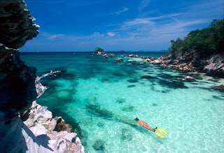
Mu Ko Similan National Park has been rated first by the U.S. publication Skin Diving of the top ten dive sites in the world. The Similan Islands in the heart of the Andaman Sea are indeed unparelled in the exotic beauty. If palnning a visit, keep in mind that anytime between December to April is recommended , with the best month being March, because the monsoons are over and the water is clear.


The national park is established in 1982 and located in Ko Phrathong Sub-district, Khuraburi District, Phang-nga Province and covers 128 square kilometers, 80,000 rais , of area, 14 square kilometers of which is land composed of all the islands put together. Locate along the western coastline of the Andaman Sea and in the Indian Ocean, rest these nine exotic granite islands created by upwellings of hot magma during the Teritiary-Cretaceous Period some 65 million years ago, then smoothed by glacial ice and the wave action of the sea.


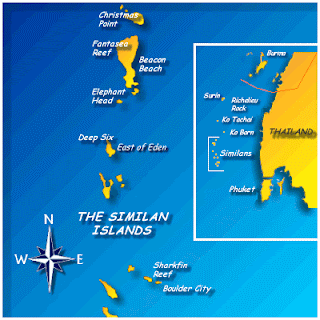
Similan is really the Malaysian word for nine, as there are nine islands in the Similan group : Ko Bangu, Ko Similan, Hin Huwagralok, Ko Payu, Ko Ha, Ko Hok, Ko Miang, Ko Payan, Kp Payang, and Ko Huyong.


In 1998, the park boundary was expanded to cover Ko Tachai which is located further north of Ko Bon and the Similan group. Then the park area becomes 140 square kilometers


Topography

Consists of numerous islands with high and steep granite mountain, beaches and rocks formation of many shapes. The shoreline of each islands are of inconsistent curves since they are situated in the outer part of the sea and are worn away directly by waves. Part of water lies in the Andaman Sea and eastern side of the Indian Ocean while the shoulder of the continent borders the western shoreline of Phang Nga province and Union of Myanmar, paralleling the Nikobar Islands of India.


There is no mud at all along beaches, beaches, so the sands are very clean, white and very fine. Some islands do have hills in the area, which are usually quite tall with the highest top of 244 meters above mean sea level, while some islands are of flat area surrounded by sand dunes and coral reefs.


Climate

Summer begins in mid February and ends in May. Rainy season starts from mid May till October with North - Western wind. Average annual temperature is 27 degree celcius with average of approximately 83% humidity all year round. Average annual rainfall is measured at 3,560 millimeters with evaporation rate of 1,708 millimeters per year. In rainy season, the park will be closed during 16 May - 14 November every year for visitors safety.


Flora and Fauna

Types of forests can be divided inth 3 main characteristics

Beach Forest - open forest with scattered plants at approximate height of not over 15 meters such as Terminalia catappa. Barringtonia asiatica, Callophyllum inophyllum. Small perennials and large shrub not exceeding 10 meters in height found are Xylocarpus gaugeticus, Herltiera littoralis, Hibiscus tiliaceus which is a smaller shrub found are Capparis micracautha, Breynia vitris idaea Fischer, Pandanus odoratissimus. Grounds covering plants common in the area are beans, Vigna sp., Spilanthes sp., Ischaemum barbatum, Lophatherum gracile, Hoya parasittrica, Asplenium nidus.


Scrub Forest - habitat for shrubs which can develop on grounds with soil depth of the exceeding 30 centimeters. A few cacti car be found while more common shrubs found are Cercus spp., Dracaena spp., Memecylon caeruleum, Cleistanhus polyphyllus.


Primary Forest - hbitation for perennials at a height of 20 meters or above such as Dipterocarpus costatus, Diptercarpus boudii, Shores spp., Lower perennials at 15 - 20 meters in height are palaquim obovatum, Eugenia denailora, Wrightia sp., 10-15 meters in height are Hydnocarpus ilicifolius, Semecarpus curtisii, Diospyros wallichii. Bambusa sp., Calamus longisetus, Plam, Amydrium medium and Bauhinia glauca are also found with other creepers and parasites such as betel pepper, bauhinia and orchid.


The most unique vegetation found only on Ko Yai in the Andaman sea are sapodilla and Nguang Chang Talay while edible plants are Manikara sp., Toumefotia argentia, Bouea oppositifolio, Lepisanthes rubiginosa, Diospyros wallichii, Neang and Copparis micracantha.


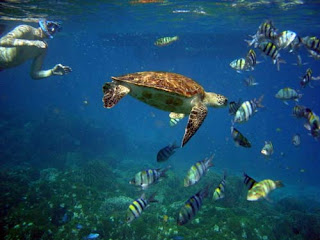
Maring and Wildlife: Beneath the sea at Mu Ko Similan National Park lies a complex ecosystem commonly called the rainforest of the sea : the coral reef. The major residents of the reef are coral and the closely related sea anemones ; of the Phylum Cnidaria, Class Anthozoa, which contains all radially symmetrical invertebrate animals. Corals and sea anemones exist as individual polyps living in either solitary or mostly colonial forms. The polyps of hard corals construct communal limestone homes which are built p into a multitude of shapes and size eventually giving rise to a coral reef. Soft corals have soft bodies made of large 
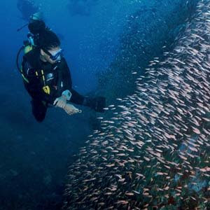
numbers of identical polyps connected by fleshy tissue (Zooxanthallae). These soft corals contain small algae within their tissues which are able to convert the sun's energy into food. This cooperative relationship is known as symbiosis and also exists in hard coral, clams and other marine organisms. There are several factors that support good environment for the reef i.e. temperature, salinity, light, wave and tide, sedimentation and nutrient. Therefore, healthy coral reef can be found easily in the Andaman Sea comparing to the Gulf of Thailand. In Andaman Sea, coral reefs are able to classified as deep water and medium water. For the deep water coral reef grow down to 30 m. Of course, in this case water allows enough light for the algae. This reef type is mostly found in Similan and Surin islands. For the rest area, medium water coral reef grow between 8-15 m beneath the surface.


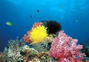
Coral can also be classified to fall into these structural categories: massive, columnar, encrusting, branching, foliceaous, laminar and free-living coral. The hard corals found in Mu Ko Similan National Park are deep water species of mostly staghorn coral types (Acropora echinata) and the smaller cauliflower shaped types (Seriatopora histrix), Many other species of marine life co-exist within the coral reef: Gorgonian sea fans , flower-like soft coral, several species of crabs, spiny painted lobsters , squid sponges, sea cucumbers and gaint clams.


Above the sea surrounding each island lies Beach forest, which steadily becomes Tropical forest further inland. Important tree species include Manilkara .

วันอาทิตย์ที่ 14 มิถุนายน พ.ศ. 2552

Samet Island


Samet Island or Koh Samed in Thai. Some may call Koh Samed, instead of Koh Samet, what an idyllic island! Once upon a time...
"Sunthon Phu" (Thailand all time great poet) had described about Koh Samet as "Koh Keaw Pitsadan" (Koh = island , Kaew = glasses , Pitsadan = magically ) in the best of his romance poems "Phra Aphai Mani". He want us to know how wonderful this white sandy beaches is !

"Phra Aphai Mani" is about a lovelorn giant - she is broken-hearted and dies on the crystal sandy beach of the island. Even though you won't see her remains anywhere on Koh Samet, but you're sure to see its cystal white sandy beaches, especially on the Had Sai Kaew or Sai Kaew Beach.


Koh Samet was named ofter the Samet Tree or the cajuput tree that grows everywhere on the island. It was declared 'Khao Lam Ya - Samet Archipelago Maritime National Park' in 1981. The park encompasses Had Mae Rumpueng-a beach on the coast of Rayong, Lam Ya Mountain and the Samet Archipelago that consists of Koh Samet , Koh Chan , Koh San Chalam, Koh Hin Khao, Koh Kang Kao , Koh Kudee , Koh Kruoy and Koh Plateen. An ecological tour can be conducted through three itineraries on Koh Samed , Koh Kudee and Lam Ya Mountain.

For more information , contact Khao Laem Ya and Mu Ko Samet Nation Park Office by
Tel : +66 3865 3034, from 8.30 a.m. to 16.30 p.m.


Located in the "Gulf of Thailand" (the eastern ocean), under the management of "Bann Phe District" of "Rayong Province" For your information, Rayong is famous for its abundance of fruits and sandy beaches, far approximately 220 km from Bangkok. Baan Phe is the seaside town, located approximately 19 km southeast of the city , Baan Phe is the best place to enjoy relaxing on a long white sandy beach while sampling sumptuous seafood. Baan Phe is a major fishing community in the province, hence , the wide rang of fresh and preserved seafood products or other local products. In addition, Baan Phe is also the departure point for Koh Samet which is far around 6 km from the coast of Rayong province.


วันเสาร์ที่ 13 มิถุนายน พ.ศ. 2552

Ko Samui


It was only the early 1970s that the first backpackers traveling on a coconut boat arrived on Ko Samui. For years after that the island just had a few bungalows and a trickle of travelers. In the early 1990s , boats full of tourists started arriving, and since then the island has soared in popularity. Samui is now the second most popular island destination in Thailand, after Phuket. Ko Samui is an oasis of natural beauty, with its white sandy beaches, dazzling coral, luscious lagoons, picturesque waterfalls, swaying coconut trees and crystal clear water. Tourism is now ahead of coconuts as the island main industry.


Development on Ko Samui is starting to take its toll, and the beaches of Chaweng and Lamai are as overcrowded as anywhere on the Costa-del-Sol. However , many quieter beaches still exist.


Popular Culture

Ko Samui was mentioned as a honeymoon destination in the 2000 movie Meet The Parents starring Robert De Niro and Ben Stiller.


Ko Samui is also where the protagonists in the movie The Beach pass through in order to rech their destination , a secret island/paradise.


Ko Samui is also mentioned in Michel Houellebecq's Platform.


Ko Samui is featured in the video game Burnout 3 although not mentioned by name. The Big Budda Statue on the island is prominently featured in the game.


Ko Samui is among 67 global locales listed in Lemon Jelly's song Ramblin'Man.


Lifesytle

Although Ko Samui is in southern Thailand, where Islam has a strong influence, the original inhabitants of the island, known as 'Chao Samui' , are predominantly Buddhist. In the past, most of the locals made their living in the coconut farming business. Nowadays , However, most work in jobs related to tourism.


Many locals have become wealthy from selling off land they have owned for decades. As a result of the extensive development of the island, many Thai-Chinese have come to Samui from the capital of Bangkok (Khung-Thep). Most of the manual labor needed to keep up with the island's growth has been provided by people native to the country's poorer north-eastern region. As a rusult, there is a wide cross section of economic classes on the island.


The south of Thailand is a melting pot of Buddhists, Thai Chinese, Muslims and traditional sea-faring gypsies. Ko Samui not seem to suffer from the religious tensions in communities along the southern border of Malaysia and Thailand, and in general the locals live in harmony. Outside of the tourist areas , the Thai language is spoken with a thick Southern dialect which is even difficult for northern Thais to understand.

With the broad mixture of cultures, Ko Samui is always celebrating some tradition or another, including western.


Event and Festival


  • Buffalo Fighting Festival

  • Ten Stars Samui Art Party

  • Bowling Championship

  • Avis Samui Tennis Open

  • The Fisherman's Village Festival

  • Triathlon Event

  • Samui Regatta

  • Full Moon Party (Ko Phangan)

Khaosan Road


Khaosan road or Khao San road (thai : ถนนข้าวสาร) is a short road in central Bangkok , Thailand. It is located in the Banglamphu neighborhood (Phra Nakhon district) about 1 km north from the Grand Palace with Wat Phra Kaew. It has developed over the years into probably the most profound worldwide example of a "backpackers' ghetto" , with cheap accommodation compared to other areas of central Bangkok. The accommodation varies from 'mattress in a box' style hotels, to full Western-standard luxury.


Many tourists use Khaosan road as their for exploring the rest of Thailand as there are many direct coaches from the street to virtually all major tourist destinations in Thailand, from Chiang Mai in the North to Ko Pha Ngan in the South . Many visitors will also take advantage of the abundance of relatively cheap travel agents to arrange visas and transport to surrounding countries such as Vietnam, Cambodia, Laos and Malaysia, though many (if not most) of these travel agents are scams of some sort, and travelers would do themselves wise to use Thai public buses instead.


Craft , paintings , clothes , pirate CDs , DVDs , fake educational diplomas , fake driver's licenses , food , second-hand books and many other useful backpacker items are among the common goods traded along the road.


Khaosan road has in recent years also become popular among local people, expecially artists and art student. The road hosts a number of pubs and bars, where people of many nationalities meet and discuss their travels. Khaosan and the streets nearby are also Bangkok's center of dancing, partying and splashing water during Thai New Year (Songkran festival) on April 13 to April 15.


It is one of Bangkok's most vibrant streets, host to people from around the world. One Thai writer described the road as " a short road that has the longest dream in the world.


"Khao san" means "raw rice" in Thai. Before it become a tourist hotspot, the street was major rice market for Bangkok.